4G-5G Mobile Coverage Studies
Need to understand what mobile coverage looks like at a location, across a region, or under different scenarios? We produce service qualification reports, installation feasibility assessments, and population coverage studies. We can also model what-if scenarios: what happens if a nearby tower goes offline, or if a new tower is proposed for a particular location. This is useful for site planners, developers, councils, and anyone making decisions that depend on knowing what the network actually delivers.
Bulk Location Analysis
Rolling out equipment across dozens or hundreds of sites nationally? Understanding signal availability at each location before you dispatch a team saves time and money. We run bulk coverage analysis across your site list to flag locations where connectivity might be an issue, so you can plan around problems rather than discovering them on arrival. This helps eliminate costly revisits and rectification work on large-scale deployments.
Greenfield Building Analysis
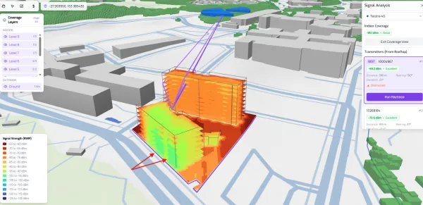
Discovering that your new building has a mobile coverage problem after it's built is expensive to fix. We can simulate a building in 3D before the first slab is poured, modelling how signal from the surrounding mobile network interacts with the planned structure. This lets you identify coverage issues early and spec an IBC or DAS into the build from the start, rather than paying for a retrofit later.
Mesh WiFi, Rajant & Silvus Network Design
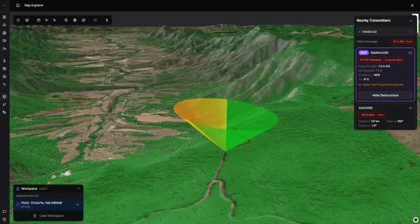
Complex outdoor environments like mine sites and large agricultural properties are challenging for wireless network planning. Terrain, vegetation, structures, and the sheer size of the coverage area all affect where access points need to go and how they'll perform. We use the simulation platform to rapidly assess feasibility and optimise AP placement across these environments. If you have LiDAR terrain data for your site, we can import it directly for an accurate, up-to-date model of the ground conditions.
Flight Path & Route Analysis
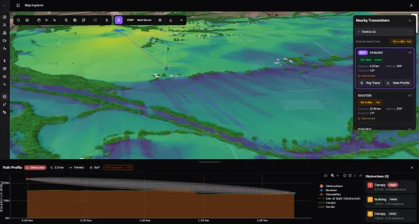
If your operation depends on vehicles, drones, or aircraft maintaining a data connection along a route, you need to know where coverage drops out before it becomes a problem. We map coverage continuity along any path, whether you're using the public mobile network, a Private 5G deployment, or a drone-specific C3 command link. The output shows you exactly where blackspots sit and what they mean for your communications.
We can provide a reporting output detailing statistical estimates for connectivity/uptime for any one service or bonded services.
Private 5G Coverage Analysis
For councils, government departments, and wireless ISPs considering Private 5G, we can model subscriber coverage across your planned service area in 3D. This includes new deployment planning, service qualification checks to specific locations, and scenario modelling to help you understand what a network will deliver before you commit to building it.
Link Design
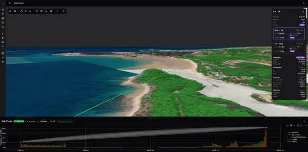
Planning a point-to-point or point-to-multipoint wireless link? We model the path between your sites using the digital twin, accounting for terrain, trees, buildings, climate, and atmospheric conditions at frequencies from 400 MHz to 100 GHz. You get a clear picture of whether the link is feasible, what performance to expect, and what hardware the job requires.
For more on how we design and install these links, see our Point to Point & Multipoint page.
Explore Our Free Tools
Some of this capability is available right now through our Tools section. You can find the strongest 4G-5G tower for your location, check a site's suitability for Starlink, and plan a wireless link with terrain calculations. They're a good starting point if you want to get a feel for what's possible.